
- Vintage
Shelby Maps
-
-

-
-
- The
earliest known map of shelby was that drawn
- by
county surveyor John Stewart as a part of
- James
Gamble's plat for the town of Shelby that
- is
recorded at the Richland County Courthouse.
- The earliest
-
-
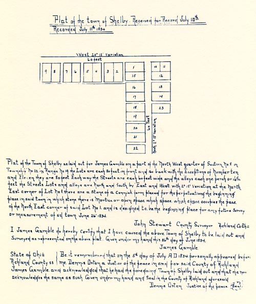
- James
Gamble's Original Plat of Shelby
- June
26, 1834
-
- The
streets that are shown intersecting
- in
this plat became what are now
- Gamble
and Main Streets.
-
-
-
-
-
-
- Not
quite A year passed before Henry Whitney
- recorded
an addition to James Gamble's Shelby.
- Drawn
on March 21, 1835 by John Stewart.
-
-
-
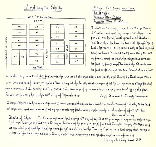
- First
Addition to James Gamble's Plat of Shelby
- recorded
May 13, 1835
-
- This
plat of lots is located between
- Main
Street and Whitney Avenue
- on
both sides of Gamble Street.
- (Directly
North and adjoining Gamble's original Plat.)
-
-
-
-
-
-
- It It
was an additional 17 years before any
- Major
additions were made. This plat would
- become
the "East Side Square" of Shelby.
- The
major streets shown are Broadway,
- Second,
High, Depot, and the unnamed street
- at
the top was called North Street.
-
- Broadway
and Second remain unchanged.
- High
became East Main Street, Depot is
- now
East Whitney, and North Street
- is
Smiley Avenue.
-
-
-
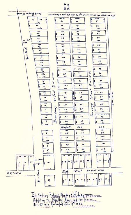
- Eli
Wilson Robert Mickey, and Henry Leyman
- Shelby
Addition recorded July 17, 1852
-
- The
Plat was drawn by County surveyor
- Warren
Scranton on December 12, 1851.
- The
application was attested by D. H. Young
- &
Jay Smiley, both of Shelby.
-
-
- (Copies
of these three maps (above) can be obtained at the
- Richland
County Recorder's office in Mansfield, Ohio.)
-
-
-
-
-
- Shelby
in 1856
- (for
a larger view, click on the above image.)
-
-
- When
this 1856 wall map was published, the three
- plats
(above) were integrated into an overall
- view
of Shelby. They are still at this point
- the
major areas of development. Note that
- what
was previously named High Street is
- here
labeled
Main Street.
-
-
-
-
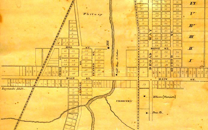
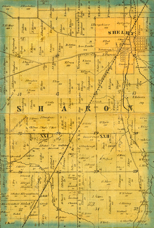
- The
Sharon Township portion the 1856 Richland County wall
- map
shows some of Shelby's immediate surroundings.
- (for
a much larger view, click on the above image.)
-
-
-
-
-
-
-
-
-
-
-
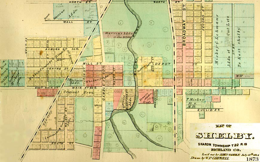
- Shelby
in 1873
-
-
-
- The
1873 Atlas Map published by A. T. Andreas of
- Chicago,
shows a Shelby that has grown dramatically
- in
the intervening 17 years since the 1856 Map.
-
- The
map denotes the location of the first plat,
- labeling
it "Original Town", and "Whitney's Addition"
- is
shown just to the north.
-
- What
was Main street in 1856 (east of Broadway)
- is
again High Street, and what is now West Main Street
- here
is labeled "East Main Street".
-
- The
latter was obviously an error, but the name
- High
Street was still in usage in 1873.
-
-
-
-
-
-
-
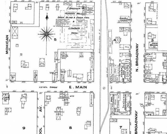
- 18
1884 Sanborn Map of Shelby East Side
- (for
a larger view, click on the above image.)
-
-
- Since
there were no known maps published in the
- Richland
County area that depicted Shelby during the
- years
between the 1873 and the 1896 atlases, it
- is
necessary to make use of a series of maps issued by
- The
Sanborn Map Company of Pelham, New York.
-
- D.
A. Sanborn's fire insurance company issued
- maps
dating from 1867 to the present, depicting
- commercial,
industrial, and residential sections
- of
some twelve thousand cities and towns in the
- United
States. By 1884 Shelby was included on
- Sanborn's
growing list of towns.
-
-
-
-
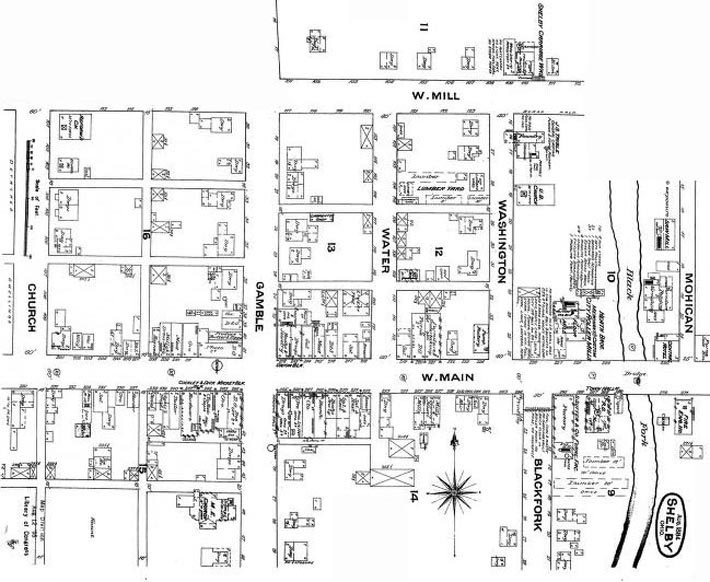
- 18
1884 Sanborn Map of Shelby West Side
- (for
two larger views, click on the left or right side of the above
image.)
-
-
-
-
- To Be
-
-
-
-
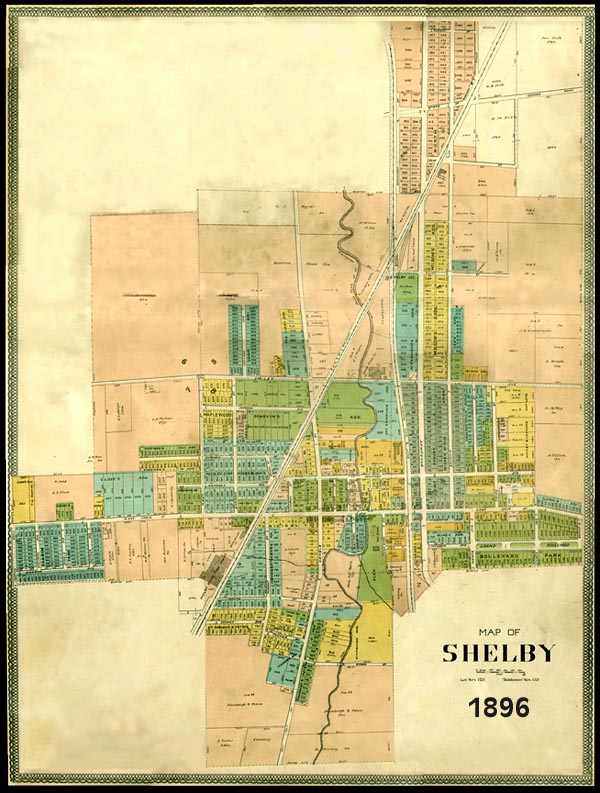
- Shelby
in 1896
- (For
an expanded view, click on an area of interest on the image above.)
- (These
images are large and may take awhile to load.)
-
-
-
- By
1896 Shelby has grown in all directions. This map
- appears
in the County of Richland Imperial Atlas
- and
Art Folio, published by the Rerick Brothers
- of
Richmond, Indiana in 1896.
-
-
-
-
-
- After
the start of the new century, Shelby began
- a
period of rapid expansion that will be detailed
- in
the Shelby early industry section.
-
- AAfter
-
-
- For
comments or additions to this section,
- please
contact us.
-


-
-
-
- Copyright
© 2000 - 2025