-
-
-
- Vintage
Shelby Maps
-
-

-
-
- 1896
-Atlas
Mapea
-
- Shelby
- (East
Central)
rl
-
-
- iest
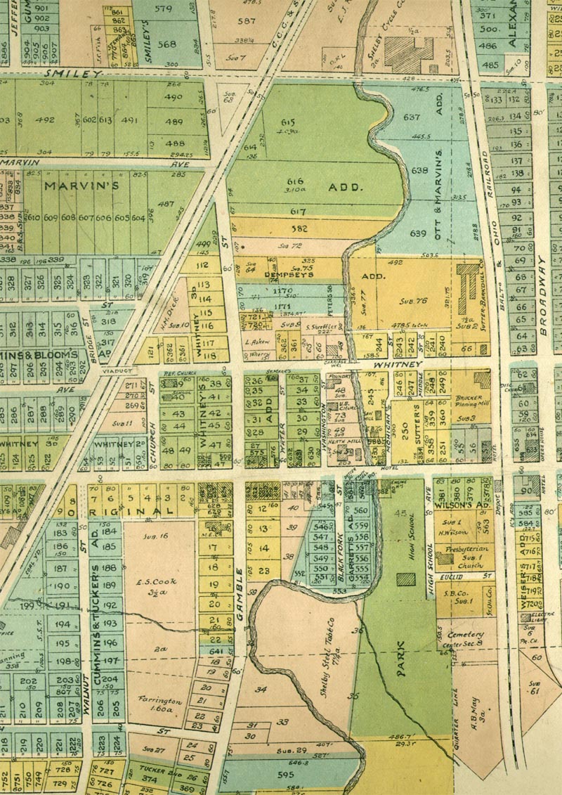
- (Use the buttons
below to navigate along Main Street or move north or south.)


-
- This
view along Main Street starting at the east side shows the Hotel
- and
Opera House on the west corners of the East side Square.
- north
along the B & O R.R. tracks is first, The Brucker Planing
Mill
- and
then, The Sutter - Barkdull Company. Just beyond Smiley Avenue
- on
the west side of Broadway is The Shelby Cycle Company.
-
- The
B & O R. R. Depot is on the west side of the tracks on the
- south
side of Main Street. Further south along the east side of the
- tracks
is the newly constructed Electric Light facility. On
- the
west side of the tracks can be seen the old Wilson Cemetery
- that
had to be moved, to make room for the expanding
- Shelby
Sales Book Company.
-
- At
the Main Street bridge can be seen the Heath Mill and the
- Central
Hotel on the north side and the Sutter Store, Town Hall,
- Post
Office and Engine House on the south side.
-
- South
along the Blackfork River can be seen the Central
- High
School (no bandstand yet). Just beyond that, the Blackfork
- makes
a Huge meander west to a point just next to South
- Gamble
Street. This meander area was to become the future site
- of
Skiles Football Field after the river was dredged and
- straightened.
Much previous to the time of this map, this low
- meander
area was used as a mill pond during Shelby's
- early
years. The small stream that flows into the Blackfork
- from
the east was moved from the path shown to one that
- now
flows under the B & O R. R. just adjacent to where the
- Wilson
Cemetery is shown on this map.
-
- What
had previously been Mill and Depot streets have been
- combined
into Whitney. On the west side of the Whitney Street
- bridge
is the Carriage Works (north) and the Foundry (south).
-
- W

- Return
to Main Map Page.
-
-
-
-
- Copyright
© 2000 - 2018